


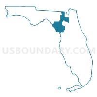
Columbia, Levy, Bradford, Gilchrist, Dixie & Union Counties PUMA, Florida
About
Outline

Summary
| Unique Area Identifier | 192563 |
| Name | Columbia, Levy, Bradford, Gilchrist, Dixie & Union Counties PUMA |
| State | Florida |
| Area (square miles) | 3,983.25 |
| Land Area (square miles) | 3,508.03 |
| Water Area (square miles) | 475.23 |
| % of Land Area | 88.07 |
| % of Water Area | 11.93 |
| Latitude of the Internal Point | 29.67046010 |
| Longtitude of the Internal Point | -82.76669870 |
Maps

Graphs
Select a template below for downloading or customizing gragh for Columbia, Levy, Bradford, Gilchrist, Dixie & Union Counties PUMA, Florida


Neighbors
Neighoring Public Use Microdata Area (by Name) Neighboring Public Use Microdata Area on the Map
- Alachua County (Outer) PUMA, FL
- Citrus County PUMA, FL
- Clay County PUMA, FL
- Marion County (North) PUMA, FL
- Nassau & Baker Counties PUMA, FL
- Putnam & St. Johns (South) Counties PUMA, FL
- Southern Georgia Regional Commission (East & Central) PUMA, GA
- Suwannee, Taylor, Madison, Hamilton & Lafayette Counties PUMA, FL
Top 10 Neighboring County (by Population) Neighboring County on the Map
- Marion County, FL (331,298)
- Alachua County, FL (247,336)
- Clay County, FL (190,865)
- Citrus County, FL (141,236)
- Putnam County, FL (74,364)
- Columbia County, FL (67,531)
- Suwannee County, FL (41,551)
- Levy County, FL (40,801)
- Bradford County, FL (28,520)
- Baker County, FL (27,115)
Top 10 Neighboring County Subdivision (by Population) Neighboring County Subdivision on the Map
- Crystal River CCD, Citrus County, FL (70,939)
- Middleburg-Clay Hill CCD, Clay County, FL (54,763)
- Lake City CCD, Columbia County, FL (50,281)
- High Springs-Alachua CCD, Alachua County, FL (38,398)
- Interlachen-Florahome CCD, Putnam County, FL (25,540)
- Fellowship CCD, Marion County, FL (25,232)
- Williston-Bronson CCD, Levy County, FL (22,622)
- Newberry-Archer CCD, Alachua County, FL (22,016)
- Keystone Heights CCD, Clay County, FL (17,852)
- Live Oak CCD, Suwannee County, FL (17,589)
Top 10 Neighboring Place (by Population) Neighboring Place on the Map
- Lake City city, FL (12,046)
- Starke city, FL (5,449)
- High Springs city, FL (5,350)
- Newberry city, FL (4,950)
- Watertown CDP, FL (2,829)
- Williston city, FL (2,768)
- Williston Highlands CDP, FL (2,275)
- Chiefland city, FL (2,245)
- Manatee Road CDP, FL (2,244)
- Trenton city, FL (1,999)
Top 10 Neighboring Unified School District (by Population) Neighboring Unified School District on the Map
- Marion County School District, FL (331,298)
- Alachua County School District, FL (247,336)
- Clay County School District, FL (190,865)
- Citrus County School District, FL (141,236)
- Putnam County School District, FL (74,364)
- Columbia County School District, FL (67,531)
- Suwannee County School District, FL (41,551)
- Levy County School District, FL (40,801)
- Bradford County School District, FL (28,520)
- Baker County School District, FL (27,115)
Top 10 Neighboring State Legislative District Lower Chamber (by Population) Neighboring State Legislative District Lower Chamber on the Map
- State House District 22, FL (176,739)
- State House District 11, FL (163,223)
- State House District 43, FL (162,052)
- State House District 12, FL (159,354)
- State House District 10, FL (151,214)
- State House District 21, FL (145,063)
- State House District 23, FL (142,648)
- State House District 176, GA (56,994)
- State House District 174, GA (48,740)
Top 10 Neighboring State Legislative District Upper Chamber (by Population) Neighboring State Legislative District Upper Chamber on the Map
- State Senate District 5, FL (515,369)
- State Senate District 3, FL (495,081)
- State Senate District 14, FL (457,489)
- State Senate District 11, FL (433,661)
- State Senate District 7, FL (432,554)
- State Senate District 7, GA (162,770)
Top 10 Neighboring 111th Congressional District (by Population) Neighboring 111th Congressional District on the Map
- Congressional District 5, FL (929,533)
- Congressional District 6, FL (812,727)
- Congressional District 4, FL (744,418)
- Congressional District 2, FL (737,519)
- Congressional District 1, GA (722,068)
- Congressional District 3, FL (659,055)
Top 10 Neighboring Census Tract (by Population) Neighboring Census Tract on the Map
- Census Tract 9705, Suwannee County, FL (9,116)
- Census Tract 2, Bradford County, FL (8,883)
- Census Tract 301.02, Clay County, FL (8,757)
- Census Tract 18.06, Alachua County, FL (8,675)
- Census Tract 1106.01, Columbia County, FL (8,674)
- Census Tract 1103, Columbia County, FL (8,456)
- Census Tract 9701.02, Levy County, FL (8,266)
- Census Tract 9601, Hamilton County, FL (8,204)
- Census Tract 9705, Levy County, FL (7,904)
- Census Tract 9504, Taylor County, FL (7,877)
Top 10 Neighboring 5-Digit ZIP Code Tabulation Area (by Population) Neighboring 5-Digit ZIP Code Tabulation Area on the Map
- 32025, FL (22,380)
- 32609, FL (18,756)
- 32024, FL (18,733)
- 32055, FL (16,570)
- 32091, FL (15,472)
- 32615, FL (14,295)
- 32656, FL (14,014)
- 32063, FL (13,429)
- 32054, FL (12,307)
- 34432, FL (12,273)